
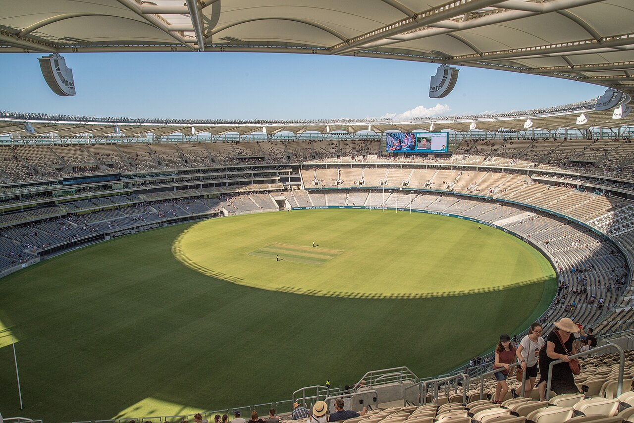
7 min walk
Optus Stadium
- Must see
- Entertainment venue
Language · 11 published
Activity · Perth
Reviewed by Elena Voss · Roavina Travel Editor

Read from the OpenStreetMap access tags; anything not listed has no tag recorded.
Set the group type to family in the planner and the day window contracts to about three quarters of a solo day.
It was established in 2015.
Matagarup Bridge is a pedestrian and cyclist bridge spanning the Swan River in Perth, Western Australia. The bridge connects the East Perth and Burswood precincts, providing access to the Optus Stadium area. Its name derives from the Noongar language, reflecting Indigenous heritage in the region. The structure serves as both functional infrastructure and an identifiable landmark within the metropolitan landscape. Open year-round as a public pedestrian and cycle crossing; no routine daily gate hours or weekly closure days are published. Main Roads treats partial or full closures as approved exceptions requiring pedestrian detours, signs and public communications. Disabled public access must remain available during partial closures.
Checked 2026-08-31 · Source
The bridge comprises a walkway and cycleway across the Swan River. As a dedicated non-vehicular crossing, it accommodates pedestrians and cyclists without motorised traffic interference. The crossing offers river views and connects to pathway networks on both banks. There are no enclosed commercial spaces, exhibition areas, or visitor facilities integral to the bridge structure itself. Users should expect an open-air crossing environment. Main Roads treats partial or full closures as approved exceptions requiring pedestrian detours, signs and public communications. Disabled public access must remain available during partial closures. Free for ordinary pedestrian and cycle access. Matagarup Zip+Climb is a separate commercial attraction and is not included.
Checked 2026-08-31 · Source
The duration of a crossing depends on individual pace and whether visitors pause to observe surroundings. A direct walk across without stopping typically takes several minutes at standard pedestrian speed. Cyclists traverse more quickly. Many visitors incorporate the bridge into longer itinerary segments, particularly when attending events at nearby Optus Stadium or exploring river foreshore areas. No guided tour duration or recommended minimum visit length is recorded. Free for ordinary pedestrian and cycle access. Matagarup Zip+Climb is a separate commercial attraction and is not included.
Checked 2026-08-31 · Source
Weather considerations may influence visitor experience, as the crossing is fully exposed. Event schedules at nearby Optus Stadium may affect pedestrian volumes significantly. Visitors seeking quieter conditions might consider timing crossings outside major event periods. Open year-round as a public pedestrian and cycle crossing; no routine daily gate hours or weekly closure days are published. The public crossing follows a continuous pedestrian-and-cycle deck between East Perth and the Burswood Peninsula. Main Roads requires disabled public access to be maintained during any partial bridge closure. The deck is at least nine metres wide and becomes wider at sheltered pause points.
Checked 2026-08-31 · Source
No ticketing mechanism or revenue collection infrastructure is mentioned. Visitors should verify current arrangements independently if uncertain. Any commercial activities or special event access arrangements connected to the bridge would fall outside standard operational parameters. The surrounding precinct may involve parking fees or event-specific charges, but these relate to adjacent services rather than bridge access itself. Free for ordinary pedestrian and cycle access. Matagarup Zip+Climb is a separate commercial attraction and is not included. The public crossing follows a continuous pedestrian-and-cycle deck between East Perth and the Burswood Peninsula. Main Roads requires disabled public access to be maintained during any partial bridge closure.
Checked 2026-08-31 · Source
The bridge connects East Perth and Burswood, accessible from both riverbanks. Public transport options serve the surrounding precincts, with train services to nearby stations and bus routes in the vicinity. The Burswood side offers connection to the Optus Stadium transport hub. From central Perth, use the Red CAT to Matagarup Bridge when event-day extensions operate, then approach from the East Perth end. On the Burswood side, Perth Stadium Station and Perth Stadium Bus Station serve the Optus Stadium precinct. East Perth Station is another named rail option, with the precinct reached via Windan Bridge. Pedestrians and cyclists can enter Matagarup Bridge directly from East Perth or Stadium Park.
Checked 2026-08-31 · Source
The bridge carries shared pedestrian and cyclist traffic, requiring awareness of passing bicycles. Weather exposure presents considerations: sun protection and hydration in warm conditions, wind exposure during adverse weather. River proximity may affect surface conditions. Event periods generate high pedestrian volumes requiring additional caution. The public crossing follows a continuous pedestrian-and-cycle deck between East Perth and the Burswood Peninsula. The deck is at least nine metres wide and becomes wider at sheltered pause points.
Checked 2026-08-31 · Source
The bridge offers river and cityscape views in both directions, with Perth's skyline visible from certain angles. The structure itself presents architectural photography subjects. Drone operation would require compliance with aviation regulations and any local restrictions not detailed here. Weather and atmospheric conditions significantly influence photographic outcomes. Visitors should exercise consideration for other bridge users when positioning for shots, maintaining walkway flow and safety. Permanent deck lights operate automatically from sunset to sunrise.
Checked 2026-08-31 · Source
It crosses the Swan River between East Perth and the Burswood Peninsula, providing direct pedestrian and cycle access toward Optus Stadium and Stadium Park.
The steel-and-concrete deck extends 370 metres from bank to bank.
The deck is at least nine metres wide and broadens at the pause points.
Traditional custodians use Matagarup for the nearby river area; the name means a place where the river is only leg-deep and can be crossed.
Official descriptions associate the flowing arches with the coming together of cultures and with forms such as black and white swans or the Wagyl, the Noongar water serpent.
The bridge opened to the public in July 2018.
Loading the interactive map…
The interactive map could not be loaded.
Last updated:
Source: OpenStreetMap contributors, Wikidata ·