
133 min walk · Bornova
Yeşilova Mound
- High
- Historic monument
Language · 11 published
Viewpoint · Menemen, İzmir
Yamanlar Dağı
Reviewed by Elena Voss · Roavina Travel Editor
This place is a Peak.
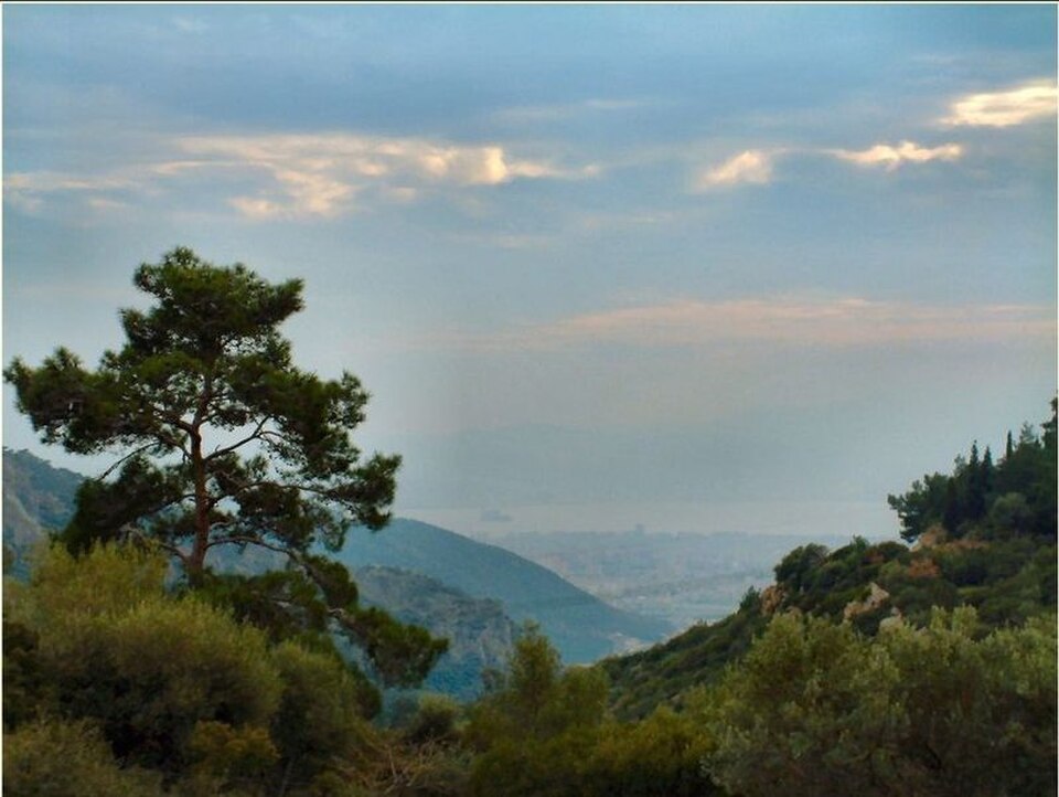
Mount Yamanlar is the mountain and nature-park setting identified by İzmir Governorate at Dededağı Tepe in Karşıyaka. Its identity comes from a forested, elevated landscape rather than a building with galleries, exhibits or a timed programme. Public descriptions frame the Yamanlar area around nature walking, cycling and photo safari, making it a destination for observing and moving through İzmir’s upland environment. Mount Yamanlar is therefore best approached as a broad outdoor place whose character comes from woodland, height, weather and the winding route from the city side. Mount Yamanlar is in Karşıyaka, İzmir. Yes. The İzmir Governorate lists Yamanlar Dağı as a nature park. The responsible public-body description identifies nature walking, cycling and photo safari as activities in the Yamanlar area. The official municipal bulletin states that no fee is charged for entry to the Yamanlar picnic area.
Checked 2026-09-02 · Source
The visit centres on forest scenery, open mountain terrain and changing views across the İzmir area. The responsible public-body material identifies nature walking, cycling and photo safari as activities in the Yamanlar area, so the experience is outdoors and self-directed. The Yamanlar picnic area is also part of the place’s practical identity, allowing an outing to include a pause for food alongside time on the mountain. Visitors should expect woodland edges, open slopes, route-dependent stopping points and landscape observation rather than a sequence of indoor attractions or formal exhibits.
Checked 2026-09-02 · Source
Allow at least half a day for the approach, a walk and time for photography or a picnic. A shorter stop can suit visitors who only want to experience the mountain setting, but the winding ascent makes a rushed visit less rewarding. Walkers and cyclists should match the outing to their chosen starting point, daylight and the effort of uphill movement. The final duration depends on how far the route continues, where visitors pause and whether food, cycling or photography forms the main purpose of the visit.
Checked 2026-09-02 · Source
Plan Mount Yamanlar for daylight, when the mountain road and outdoor terrain are easiest to negotiate and landscape photography benefits from natural visibility. İzmir Governorate has issued seasonal forest-entry bans covering the Yamanlar–Karagöl forest area during officially declared fire-risk periods, and those decisions can prevent an otherwise planned outing. Cooler parts of the day are more comfortable for walking and cycling, especially on uphill sections. Weather affects visibility, road comfort and the appearance of the forest, so conditions directly shape the experience.
Checked 2026-09-02 · Source
No admission charge is recorded for Mount Yamanlar in the responsible-public-body material used for this guide. Mount Yamanlar is presented as an outdoor mountain and nature-park area rather than a controlled museum-style venue with a published adult ticket. The Yamanlar picnic area is described as free in an orienteering event bulletin, but that event document does not establish a general admission tariff for every part of the mountain visitor area. No payable ticket should therefore be expected from the recorded information.
Checked 2026-09-02 · Source
İzmir Governorate places Mount Yamanlar in Karşıyaka at Dededağı Tepe. The public approach is from the Karşıyaka and Yamanlar side, followed by a steep, winding mountain road. ESHOT route 741 is documented as Yamanlar Köyü–Karşıyaka, which can serve the settlement side of the journey. The final ascent continues by road, so the route record should not be read as a dedicated service to every mountain location, picnic point or trail access point. Plan the onward section around the intended stopping area.
Checked 2026-09-02 · Source
Treat Mount Yamanlar as a mountain and forest destination, not as an urban park with a level promenade or fully documented visitor infrastructure. The approach is steep and winding, while the public descriptions emphasise walking, cycling and photo safari. Seasonal forest-entry bans may cover the Yamanlar–Karagöl area during fire-risk periods, making official access notices important before departure. Visitors should plan a self-sufficient outdoor excursion and assess the terrain before committing to the ascent.
Checked 2026-09-02 · Source
Landscape photography is one of the clearest reasons to visit Mount Yamanlar: the forested mountain, elevated position and changing daylight provide a setting for a photo-safari outing. Use woodland edges, road-side clearings and changes in height to vary compositions, while choosing stopping places away from traffic. Visibility depends on weather, and seasonal forest restrictions can reduce the route available. Walkers and cyclists should keep attention on uneven ground and moving vehicles while positioning for photographs. Daylight also helps reveal the contrast between the mountain landscape and the İzmir area below.
Checked 2026-09-02 · Source
Mount Yamanlar is in Karşıyaka, İzmir, at the Dededağı Tepe area identified by İzmir Governorate.
İzmir Governorate lists Yamanlar Dağı as a nature park. The available information establishes that listing and its associated official access notices, but does not provide a broader legal designation in the material used for this guide.
The responsible public-body description identifies nature walking, cycling and photo safari in the Yamanlar area. These are outdoor activities in the mountain landscape, not scheduled indoor attractions.
No admission charge is recorded for Mount Yamanlar in the responsible-public-body material used for this guide. The Yamanlar picnic area is described as free in an orienteering event bulletin, but that document does not establish a general admission rule for the mountain visitor area.
ESHOT route 741 is documented as Yamanlar Köyü–Karşıyaka and can reach the settlement side. The mountain ascent continues by road, and the available transport information does not document a dedicated public-transport stop for every mountain access point.
Yes. İzmir Governorate has issued seasonal entry bans covering the Yamanlar–Karagöl forest area during officially declared fire-risk periods. Those decisions can affect whether an outdoor visit is possible.
Loading the interactive map…
The interactive map could not be loaded.
Last updated:
Source: OpenStreetMap contributors, Wikidata ·