.jpg)

2 min walk
Al-Amir Sorghotmosh Al-Nassery
- Notable
- Place of worship
Language · 11 published
Historic monument · Cairo
Reviewed by Elena Voss · Roavina Travel Editor
| Monday | 09:00 – 17:00 |
|---|---|
| Tuesday | 09:00 – 17:00 |
| Wednesday | 09:00 – 17:00 |
| Thursday | 09:00 – 17:00 |
| Friday | 09:00 – 17:00 |
| Saturday | 09:00 – 17:00 |
| Sunday | 09:00 – 17:00 |
Checked 2026-08-31 · Source
Read from the OpenStreetMap access tags; anything not listed has no tag recorded.
Set the group type to family in the planner and the day window contracts to about three quarters of a solo day.
Historic Cairo is a UNESCO World Heritage site encompassing one of the world's oldest Islamic cities, founded in the tenth century. It became the new centre of the Islamic world, reaching its golden age in the fourteenth century. The area contains mosques, madrasas, hammams, fountains, and a dense urban fabric that accumulated over centuries. The site was inscribed on the World Heritage List in 1979 under criteria (i), (v), and (vi). The official Al-Muizz monument route is open daily 09:00–17:00; no weekly closure day is listed. UNESCO maps five components: Al-Fustat; the combined Mosque of Ahmed Ibn Tulun, Citadel, Fatimid nucleus and necropolis component; Al-Imam ash-Shaf'i Necropolis; As-Sayyidah Nafisah Necropolis; and Qayitbay Necropolis.
Checked 2026-08-31 · Source
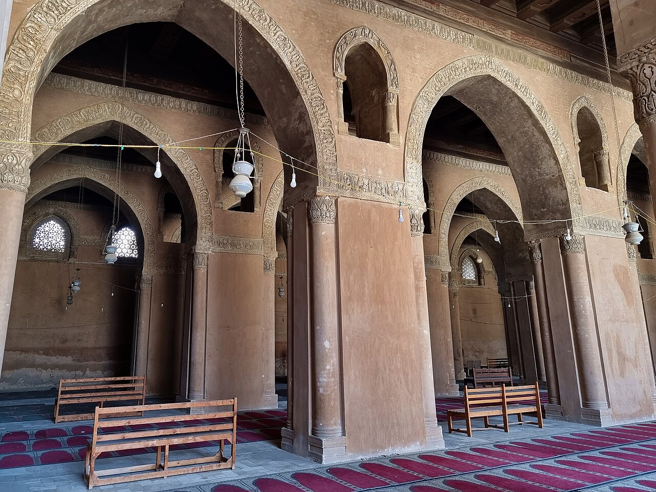
The urban landscape contains Fatimid, Ayyubid, Mamluk, and Ottoman architectural layers. Notable monuments include the Mosque of Ibn Tulun, one of the oldest surviving mosques in Africa, and the complex of Sultan al-Mansur Qalawun. The area encompasses the famous Khan al-Khalili bazaar district, Coptic Christian heritage sites including churches, and numerous caravanserais, fountains, and residential structures. The density of historic monuments in this relatively compact area is considered exceptional. No single production district identity exists within this broader heritage landscape.
Checked 2026-08-31 · Source
Visitors should plan for multiple days to explore Historic Cairo adequately given its extensive boundaries and monument density. A superficial circuit of major monuments requires at minimum a full day. Serious architectural or historical study demands substantially longer engagement. The area's narrow streets, market crowds, and dispersed sites slow movement considerably. Many travellers combine repeated visits with breaks rather than attempting comprehensive coverage in one attempt. The bazaar districts alone warrant several hours of wandering. Step-free movement is not continuous across the extensive historic district.
Checked 2026-08-31 · Source
Cairo experiences hot summers and mild winters, with peak heat from June through September making extended walking uncomfortable. Cooler months from November through March offer more pleasant conditions for street-level exploration. Ramadan timing affects shop hours and food availability in surrounding commercial areas. Friday prayer times may affect access to functioning mosques. The official Al-Muizz monument route is open daily 09:00–17:00; no weekly closure day is listed. Step-free movement is not continuous across the extensive historic district. UNESCO’s planning study describes a pre-modern pedestrian street network, congestion and reduced walkability, and identifies improved pedestrian accessibility as a required intervention.
Checked 2026-08-31 · Source
Individual monuments within Historic Cairo may have separate admission arrangements. Some functioning religious buildings permit entry without charge while requesting appropriate dress and behaviour. Others may require tickets purchased on site. Photography permits inside monuments may involve additional fees where such policies exist. Al-Muizz area-entry adult ticket: EGP 220 for foreigners and EGP 20 for Egyptians. It covers the ministry’s listed monument group but excludes Wekalet Bazaraa and Bayt Al-Suhaymi, which require separate tickets. Historic Cairo has no single admission covering the entire urban World Heritage property.
Checked 2026-08-31 · Source
Historic Cairo occupies central Cairo between modern downtown and the Citadel. The Cairo Metro serves the general area with stations including Bab el-Shaaria and Attaba providing access to different quarters. Taxis and ride-hailing services operate throughout but face congestion in narrow historic streets. For the northern Fatimid and Al-Muizz area, use Bab El Shaaria station on Metro Line 3; Cairo Governorate identifies it as the closest station to Islamic Cairo’s northern side. Al-Muizz Street can then be followed south from Bab al-Futuh toward Bab Zuwayla. Ataba, an interchange between Lines 2 and 3, is the alternative approach from downtown.
Checked 2026-08-31 · Source
Street-level conditions in dense historic quarters demand situational awareness. Traffic in narrow lanes includes motorcycles and delivery carts moving unpredictably. Crowd density in market areas creates pickpocketing opportunities. Aggressive vendor approaches occur in tourist-frequented bazaar sections. Dress modestly for religious site visits; shoulders and knees should be covered. Some monument interiors have uneven surfaces, poor lighting, or steep stairs without handrails. Step-free movement is not continuous across the extensive historic district. Accessibility varies across streets and independently operated monuments; the World Heritage property does not provide a documented continuous step-free visitor route.
Checked 2026-08-31 · Source
Exterior photography of historic monuments is generally possible from public thoroughfares. Interior photography policies vary by individual site and may be prohibited, permitted freely, or require purchase of a camera permit. Functioning mosques may restrict photography during prayer times or entirely. Local residents in market areas may object to unsolicited portrait photography. Tripod use in crowded streets is impractical and may attract security attention. Early morning and late afternoon provide the most favourable natural lighting for architectural exteriors given Cairo's strong sunlight.
Checked 2026-08-31 · Source
UNESCO maps five components: Al-Fustat; the combined Mosque of Ahmed Ibn Tulun, Citadel, Fatimid nucleus and necropolis component; Al-Imam ash-Shaf'i Necropolis; As-Sayyidah Nafisah Necropolis; and Qayitbay Necropolis.
UNESCO inscribed Historic Cairo in 1979 under criteria (i), (v) and (vi), recognizing its architectural masterpieces, surviving historic urban fabric and importance to medieval political, intellectual and commercial life.
The Fatimid capital was founded in 969. UNESCO also identifies earlier settlements incorporated into Historic Cairo, including Al-Fustat from 642, Al-Askar from 750 and Al-Qata'i from 879.
Al-Muizz Street runs north–south between Bab al-Futuh and Bab Zuwayla. The Ministry of Tourism and Antiquities identifies 29 monuments along the route, spanning the 10th through 19th centuries.
It is both a World Heritage property and an active urban district. UNESCO records surviving neighbourhoods, markets, crafts and religious buildings integrated into the areas they historically served.
The ticket covers the Qalawun Group, Suleyman Agha Al-Selehdar Mosque and Sabil, Al-Kamil School, Al-Nasir Muhammad Ibn Qalawun Mosque and School, Sultan Barquq Mosque, Musa Bin Maimun Temple, Hammam Inal and Amir Bishtak Palace; Wekalet Bazaraa and Bayt Al-Suhaymi are excluded.
Loading the interactive map…
The interactive map could not be loaded.

Last updated:
Source: OpenStreetMap contributors ·