

2 min walk
H'Art Museum
- Must see
- Museum
Language · 11 published
Viewpoint · Amsterdam
Reviewed by Elena Voss · Roavina Travel Editor
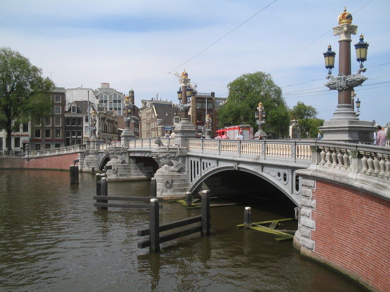
This place is a Viewpoint. It was established in 1883. It carries the Rijksmonument heritage designation.
Blauwbrug is a historic road bridge over the Amstel in central Amsterdam, linking the Rembrandtplein side of the river with the Waterlooplein side. Its identity comes from the crossing itself: an active roadway, pedestrian edges, decorative ironwork and lampposts, and open views along the water. The bridge is not an enclosed attraction or museum. It is a compact piece of civic architecture best understood while walking through the surrounding centre, where the river, traffic and nearby squares form one continuous urban scene. The blue-painted appearance gives the bridge its familiar Dutch name, while the late-nineteenth-century structure adds a more ornamental character than a purely utilitarian crossing. Its appeal is immediate and physical: you stand above the Amstel, see movement on the water, and experience how a working bridge connects two busy parts of the city. That combination makes Blauwbrug specific to Amsterdam’s riverfront rather than interchangeable with a formal indoor sight.
Checked 2026-08-26 · Source
There is no interior to explore at Blauwbrug. The visit takes place across an open bridge deck, with the Amstel beneath it and Amsterdam’s built-up centre continuing along both banks. Look at the bridge’s structure, roadway, pedestrian edges and decorative lamps, then turn toward passing boats and the waterfront buildings. Stone or masonry abutments anchor the crossing at the riverbanks, while the open sightlines make the water part of the experience. There are no exhibitions, staffed interpretation areas or dedicated visitor facilities on the bridge itself. Nearby streets and squares supply the wider context, so Blauwbrug works especially well as one stop within a self-guided city walk. Its details reward a slower look: compare the ornamental elements with the practical movement of bicycles, pedestrians and vehicles, then use the river corridor to understand the bridge as both architecture and infrastructure.
Checked 2026-08-26 · Source
Allow around two to five minutes for a direct walk across Blauwbrug, depending on your pace and the amount of pedestrian movement. A more useful pause takes about ten to fifteen minutes, giving you time to study the bridge details, watch river traffic and look along the Amstel. The crossing can also become a longer part of a route between Rembrandtplein, the waterfront and Waterlooplein. There is no fixed tour sequence; your timing depends on whether you are simply crossing, observing the structure or taking photographs. Travellers who enjoy urban architecture may naturally stay beyond the basic pause to examine the lamps, ironwork, roadway and views from both sides. Build in extra time if your walk continues toward nearby squares or markets, since the bridge is most rewarding as part of a connected central route rather than as an isolated destination.
Checked 2026-08-26 · Source
Blauwbrug is an outdoor urban crossing, so the experience changes with daylight, weather and activity in central Amsterdam. Daylight makes the river, façades and structural details easier to see. Early or late light can add depth to photographs, while evening brings a different cityscape as the surrounding centre becomes livelier. Wind and rain are exposed conditions on the bridge, with no shelter built into the crossing. Choose the moment that suits your walk and preferred atmosphere rather than planning around a timed attraction schedule. Morning can feel calmer for looking closely at the structure, whereas busier periods bring more movement across the roadway and walkways. Seasonal daylight changes the visual balance between water, sky and buildings, but the practical experience remains that of an open public crossing exposed to Amsterdam’s weather.
Checked 2026-08-26 · Source
Blauwbrug is a public road bridge, not a ticketed attraction, and crossing it requires no admission ticket. Pedestrian, cyclist and vehicular passage are part of moving through the city rather than entering a paid site. A walking, cycling or sightseeing tour may include the bridge, but any charge belongs to that separate operator. Plan Blauwbrug as free public urban space within an Amsterdam route; costs for transport, food or organised activities elsewhere are outside the bridge crossing itself. There is no gate, ticket desk or visitor-entry procedure described for the crossing. This makes it easy to add spontaneously when walking between the two sides of the Amstel, while any planned expenditure should be associated with the surrounding itinerary rather than with Blauwbrug itself.
Checked 2026-08-26 · Source
Blauwbrug crosses the Amstel between the Rembrandtplein and Waterlooplein areas, making it easy to add to a central Amsterdam walking route. Approach from either riverbank and continue across the public crossing. Tram services operate to stops near both banks, while walking from Amsterdam Central Station takes approximately twenty to thirty minutes through the historic centre. Cycling is a natural way to reach this part of the city using Amsterdam’s designated cycle routes. Driving is less convenient because central streets have traffic restrictions and parking constraints. The bridge’s position also makes it practical for visitors staying in central accommodation, since many routes through the old city can reach the river without a separate transfer. Once nearby, follow the riverfront approach and keep to the space intended for your mode of travel as you cross.
Checked 2026-08-26 · Source
Blauwbrug is an active city crossing, so stay aware of the roadway and bicycles moving through the central Amsterdam traffic mix. Keep to the appropriate pedestrian space and avoid stopping where you block people travelling across. The river and architecture invite close attention, but photographs should never take priority over traffic awareness or a clear route for others. Rain, wind and cold can make the exposed crossing uncomfortable. Crowding may increase when nearby squares, markets, nightlife or sightseeing routes are busy. Wet or icy surfaces can reduce grip, and the open bridge provides no refuge from sudden weather. Near the parapets, keep your position secure and leave room for other users. Treat the crossing as transport infrastructure first and a viewing point second, particularly when traffic or cycling flow is heavy.
Checked 2026-08-26 · Source
Use Blauwbrug as a viewpoint into the Amstel corridor rather than photographing only the bridge deck. From the crossing, frame the river, passing boats, opposite-bank buildings and the lines of the waterfront, then turn back toward the decorative ironwork and lamps for closer architectural images. Morning and evening light can separate the bridge from the water and produce reflections; overcast conditions suit quieter detail shots. A phone or small camera is easiest in the pedestrian space. Keep clear of traffic and do not obstruct the walkway. Try both directions across the bridge: one composition can emphasise the river’s length and urban façades, while another can make the bridge’s own ornamental elements the subject. If you use a tripod, place it only where it does not narrow the passage, and avoid leaning toward the roadway or parapet for a better angle.
Checked 2026-08-26 · Source
Yes. Blauwbrug is a public road bridge over the Amstel and can be included in a central Amsterdam walking route between the Rembrandtplein and Waterlooplein areas.
No admission ticket is required for the bridge crossing itself. If a commercial sightseeing or walking tour includes Blauwbrug, any fee is for that separate organised activity.
The crossing gives views along the Amstel and toward central Amsterdam’s surrounding buildings, streets and river activity. The bridge’s own structure, decorative ironwork and lamps are also part of the scene.
A direct crossing takes roughly two to five minutes. Allow about ten to fifteen minutes if you want to pause for river views, observe the structure or take photographs.
It fits naturally into a route connecting the Amstel waterfront with Rembrandtplein and Waterlooplein. Treat it as a brief architectural and city-view stop within a longer central walk.
The bridge offers river and city views as well as close architectural details. Use the pedestrian space, keep clear of traffic and avoid stopping in a way that obstructs people crossing.
Loading the interactive map…
The interactive map could not be loaded.

Last updated:
Source: OpenStreetMap contributors, Wikidata ·