

1 min walk
Hai Van Gate
- Must see
- Historic monument
Language · 11 published
Historic monument · Da Nang
Đèo Hải Vân
Reviewed by Elena Voss · Roavina Travel Editor
| Monday | 06:00 – 21:30 |
|---|---|
| Tuesday | 06:00 – 21:30 |
| Wednesday | 06:00 – 21:30 |
| Thursday | 06:00 – 21:30 |
| Friday | 06:00 – 21:30 |
| Saturday | 06:00 – 21:30 |
| Sunday | 06:00 – 21:30 |
Checked 2026-08-31 · Source
Read from the OpenStreetMap access tags; anything not listed has no tag recorded.
Set the group type to family in the planner and the day window contracts to about three quarters of a solo day.
This place is a Attraction.
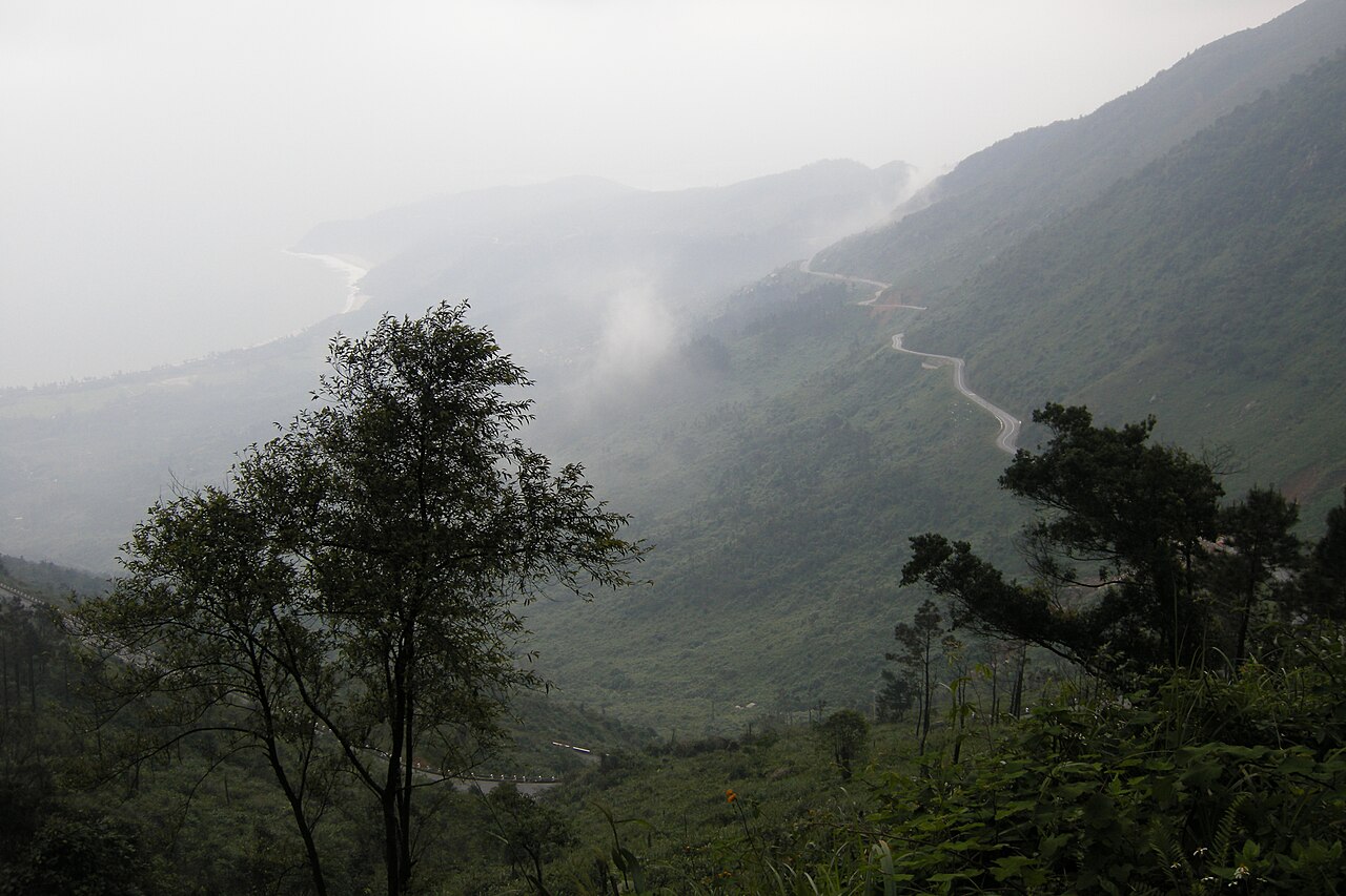
Hai Van Pass is a dramatic mountain pass on the border of Da Nang and Thua Thien-Hue provinces. The name translates to Ocean Cloud Pass, reflecting its mist-shrouded peaks and coastal vistas. This route traverses the Truong Son mountain range, offering commanding views of the South China Sea on one side and forested slopes on the other. Historically significant as a strategic military point and ancient boundary marker between kingdoms, the pass remains a celebrated scenic corridor for travellers moving between central Vietnam's major cities.
Checked 2026-08-31 · Source
The pass features a winding paved road with multiple viewpoints and stopping areas. A French-built railway tunnel runs beneath the road, part of the North-South railway line. Near the summit stands an old gatehouse marking the former boundary between Dai Viet and Champa kingdoms. Small vendor stalls appear intermittently along the route. The surrounding landscape comprises dense tropical forest, steep granite cliffs, and occasional waterfalls visible during wet conditions. No formal visitor centre or structured facilities exist at this open mountain crossing.
Checked 2026-08-31 · Source
Traversing the pass by motor vehicle typically requires forty minutes to one hour without extended stops. Many visitors allocate half a day including photography pauses and viewpoint exploration. The route spans approximately twenty-one kilometres from base to summit descent. Cycling demands substantially longer, often three to four hours depending on fitness and weather conditions. Tour operators frequently combine Hai Van Pass with Lang Co Bay or Hue city, creating full-day itineraries. Independent travellers should budget additional time for unpredictable mountain weather and traffic patterns.
Checked 2026-08-31 · Source
Daily 06:00–21:30 The Da Nang City Tourism Information Portal lists daily opening from 06:00 to 21:30 and describes the pass as accessible year-round; there are no regular closure days. The portal advises against travelling during storms, at night, or in thick fog because the road is steep and winding. Dry season months from February to August generally offer clearer visibility and safer road conditions, though morning fog remains common year-round. Wet season travel increases landslide risks and reduces panoramic views. Sunrise and early morning periods provide the most dramatic cloud formations and softer light for observation. Midday hours tend to clear fog but introduce harsher visibility conditions.
Checked 2026-08-31 · Source
The Hai Van Pass scenic road is free. Admission to the separately managed Hai Van Gate historic site at the summit is 70,000 VND per person per visit under Resolution 05/2026/NQ-HĐND, effective 2 June 2026 through 31 December 2028. No entry fee applies to traverse Hai Van Pass itself as it remains a public thoroughfare. Motorcycle rental in Da Nang represents the primary expense for independent visitors, with numerous operators in the city centre. Guided tour packages vary by provider and inclusions. Fuel costs depend on vehicle type and round-trip versus one-way arrangements. Some viewpoint parking areas may involve informal attendant fees. Travellers should verify current rental rates and insurance terms directly with established providers rather than informal street vendors.
Checked 2026-08-31 · Source
Hai Van Pass is on National Route 1A, about 20 km north of central Da Nang. A private car or taxi takes about 30 minutes to reach the summit from Da Nang; ask the driver specifically for the scenic pass road because most interprovincial buses use the Hai Van Tunnel. The official listing places the pass 22 km from Da Nang Railway Station, with taxi or motorbike for the onward journey, and 28 km from Da Nang International Airport, with taxi recommended. Motorbikes cannot enter the road tunnel and must use the pass road or the tunnel shuttle service. The pass lies approximately twenty-five kilometres north of Da Nang city centre, accessible via National Route 1A turning onto the mountain road. Motorbike rental provides the most common independent access method.
Checked 2026-08-31 · Source
The paved pass road can be experienced from a private car or taxi. Access to the elevated Hai Van Gate remains limited by a rough staircase, so the historic structures and upper viewpoints are not step-free. Toilets are provided within the Hai Van Gate site; Da Nang authorities assigned development of the supporting parking and public-toilet area to the local district. Steep gradients, sharp curves, and unpredictable fog demand cautious driving regardless of experience level. Heavy truck traffic occasionally shares the narrow road. Loose gravel and wet surfaces amplify accident risks during and after rainfall. Temperature drops significantly at elevation; appropriate layering prevents chill during extended stops. Limited emergency services operate in this remote mountain corridor. Fuel stations are absent along the pass itself.
Checked 2026-08-31 · Source
The northern viewpoint near the summit gatehouse offers the most celebrated panoramas encompassing both coastal and mountain scenery. South-facing overlooks reveal Da Nang bay and distant city development. Morning mist creates atmospheric layering effects though obscures distant horizons. Midday provides clearer long-range visibility with harsher contrast. The railway tunnel portals and historic gatehouse structure offer architectural interest. Drone operation requires awareness of airspace restrictions near military installations. Tripod stability challenges arise from persistent winds at exposed viewpoints. Weather changes rapidly; photographers should prepare for sudden fog envelopment that eliminates visibility entirely.
Checked 2026-08-31 · Source
The official Da Nang tourism listing gives daily hours of 06:00–21:30, with no regular closure day.
Driving the scenic pass road is free. The separately managed Hai Van Gate historic site charges a general admission fee of 70,000 VND per person per visit.
The pass is about 20 km north of central Da Nang; the official tourism portal estimates roughly 30 minutes by private car or taxi to the summit.
No. Motorbikes are prohibited inside the tunnel; riders use the scenic pass road or the tunnel shuttle service.
The mountain road is approximately 20–21 km long, and Hai Van Gate stands near the summit at about 496 metres above sea level.
The official tourism portal identifies March through August as the dry season with more stable weather and clearer visibility; September through December brings more rain, slippery surfaces, and fog.
Loading the interactive map…
The interactive map could not be loaded.

Last updated:
Source: OpenStreetMap contributors, Wikidata ·