

23 min walk
Pampus
- Notable · Heritage site
- Historic monument
Language · 11 published
Nature site · Amsterdam
Reviewed by Elena Voss · Roavina Travel Editor
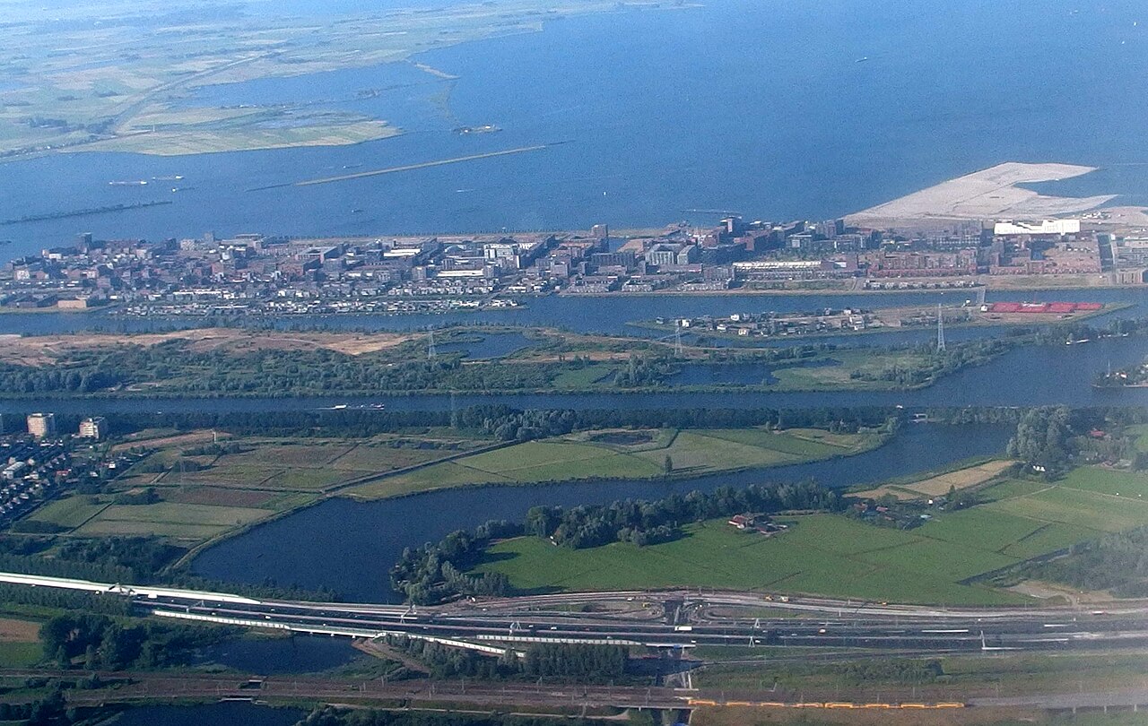
This place is a Body of water. It carries the Ramsar site heritage designation.
IJmeer is the freshwater lake on Amsterdam’s eastern edge, where the city’s built shoreline opens into a broad, low horizon. The Amsterdam-facing waterfront is closely associated with IJburg, an archipelago of artificial islands whose quays, bridges, homes and parks meet the lake. Across the water lie the wider IJsselmeer landscapes and the direction of Flevoland. There is no single entrance or central visitor building: IJmeer is an outdoor landscape understood through its water, engineered edges, open sky and changing relationship with Amsterdam. Its character is especially clear when viewed from the IJburg side, where contemporary urban form sits directly beside a large freshwater expanse.
Checked 2026-08-26 · Source
The IJmeer experience is distributed rather than arranged as a conventional attraction. Open water, waterfront paths, public green areas and the developed edge of IJburg make up the setting. Diemerpark adds nearby lawns and waterside space on the southern side, while the IJburg islands provide promenades, bridges, residential architecture and changing views across the lake. The water also forms habitat for ducks, geese and other aquatic birds, and it is used by boats. Plan around a chosen shoreline section: the area does not offer one sequence of galleries, exhibits or facilities to follow.
Checked 2026-08-26 · Source
Allow about 45 to 60 minutes for a focused visit to one public waterfront, with time to pause, take photographs and walk a short stretch. Combining the shore with Diemerpark and selected IJburg streets creates a two- to three-hour outing, especially when you stop to look across the lake or explore the island layout. Cycling makes a wider circuit practical. Boating or swimming is a separate activity requiring its own preparation. Because access points are dispersed, choose the route and endpoint first; the time needed depends on how much shoreline and neighbourhood you intend to connect.
Checked 2026-08-26 · Source
IJmeer can be visited in every season, with the experience shaped by daylight, wind and temperature. Summer is generally the most comfortable period for lingering beside the water, cycling and combining the shore with nearby parks. Spring and autumn can bring dramatic skies and quieter paths, but conditions change quickly. Winter makes the lake’s scale and exposure particularly apparent; warm, weatherproof layers are useful because open stretches provide little shelter. Check the forecast before committing to a long cycle or water activity, and allow your plan to change if wind or rain makes the exposed waterfront uncomfortable.
Checked 2026-08-26 · Source
Viewing IJmeer and walking through its public-edge spaces does not involve a general admission ticket. It is an open natural and urban waterfront area rather than a gated attraction with a standard entry fee. Your visit may still involve separate costs for transport, food, equipment hire or a commercial boat outing, each arranged by its own provider. Those expenses are not admission to IJmeer itself. The lake has no single ticket office, paid visitor circuit or uniform charge covering its dispersed shoreline and parks.
Checked 2026-08-26 · Source
From central Amsterdam, tram 26 serves IJburg and brings visitors toward the IJmeer-facing side of the city; continue on foot to the particular shore, park or viewpoint selected for the visit. Buses operate in surrounding districts. Cycling is a natural approach, with dedicated routes leading east through Diemen and along the waterfront. By car, use the A10 and connecting roads, then check parking at the chosen destination because availability varies. Walking works from eastern neighbourhoods, while reaching the area by water depends on the vessel and its landing point.
Checked 2026-08-26 · Source
IJmeer is exposed open water, so wind can make a mild forecast feel much colder and conditions can change quickly. It is not a sheltered canal environment. Take care near the edge and do not treat every attractive shoreline as suitable for entering the water. Developed IJburg and more natural sections have different path surfaces and facilities; quieter stretches may offer less support if you need help. Cyclists should share paths considerately. For swimming or another water activity, follow the rules and safety information at the specific bathing or launch location.
Checked 2026-08-26 · Source
IJmeer suits photographs built around space: a low horizon, broad water, layered cloud and the changing geometry of IJburg’s islands. Quays, bridges and contemporary buildings create strong straight lines against the lake, while Diemerpark and quieter edges add softer foregrounds. Early or late daylight can reveal texture on the water, and unsettled weather can give the scene more drama. A wide lens conveys the scale; a longer lens can isolate birds, distant shorelines or architectural details. Secure tripods and exposed equipment in the wind, which is part of the waterfront’s visual and practical character.
Checked 2026-08-26 · Source
Swimming locations and conditions vary around the lake. Use an official bathing area where one is provided and follow the safety and water-quality information displayed at that location. An attractive shoreline is not necessarily intended for entering the water, so choose a designated place for swimming.
Yes. Tram 26 serves IJburg from Amsterdam and brings visitors toward the IJmeer-facing side of the city. Buses serve surrounding areas as well. The final walk depends on the precise shoreline, park or waterfront point chosen, because IJmeer has dispersed access rather than one central entrance.
Dining options are available in the wider IJburg area, but IJmeer itself is an open landscape rather than a single venue with an on-site café. Select the waterfront section first, then use nearby commercial areas for food and drinks. Availability depends on the particular place you visit.
Accessibility varies by route and shoreline section. Developed areas around IJburg generally provide more predictable paved surfaces, while natural edges may be uneven. There is no single entrance or uniform surface for the whole IJmeer area, so the chosen destination and approach determine the practical experience.
Waterbirds are a characteristic part of the lake environment, including ducks, geese and other aquatic species. Sightings depend on season, weather, time of day and viewing point. Quieter shoreline sections may offer better observation conditions than busy urban edges, so a patient pause can be rewarding.
A dedicated IJmeer guided service is not confirmed. The area can nevertheless be part of broader commercial water excursions in Amsterdam, with availability depending on the provider and departure point. Any such outing is a separate activity with its own arrangements, timing and price.
Loading the interactive map…
The interactive map could not be loaded.
Last updated:
Source: OpenStreetMap contributors, Wikidata ·