Check the spelling, or browse the hierarchy from the country page.
City guide · Canada
Nature sites, Theme: Viewpoints, Good for families in Vancouver, Canada
Vancouver is a compact waterfront core surrounded by distinct neighbourhoods, parks and mountains. Downtown contains the central business district, West End, Co...
Editorial responsibility: Elena Voss
· Roavina Travel Editor
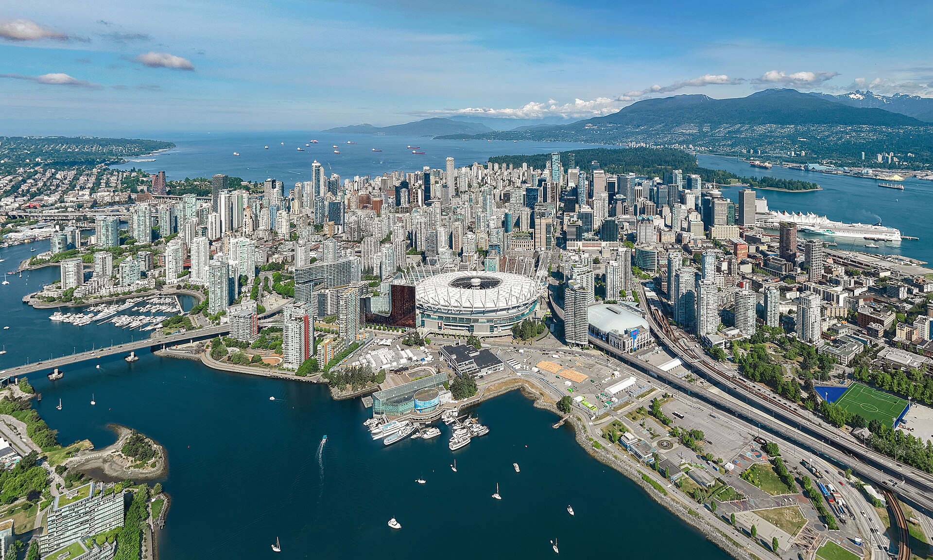
Vancouver is a compact waterfront core surrounded by distinct neighbourhoods, parks and mountains. Downtown contains the central business district, West End, Coal Harbour and Yaletown; Stanley Park forms its western edge. Gastown and Chinatown sit east, while False Creek separates downtown from Granville Island, Kitsilano and Mount Pleasant. North Vancouver is across Burrard Inlet and belongs to the wider visitor geography rather than the downtown walking grid.
November · November in Vancouver has mean high 9.0°C, mean low 3.1°C, rainfall 181.0 mm, 19.7 rain days. Cooler temperatures and persistent rain make a weather-flexible route sensible. A flexible November itinerary in Vancouver is more realistic than a long exposed walking day.
January: viable with meaningful trade-offs
Jan
February: viable with meaningful trade-offs
Feb
March: viable with meaningful trade-offs
Mar
April: good time to visit
Apr
May: good time to visit
May
June: good time to visit
Jun
July: good time to visit
Jul
August: good time to visit
Aug
September: good time to visit
Sep
October: viable with meaningful trade-offs
Oct
November: viable with meaningful trade-offs — current month
The list is built from real place data, so an empty result means the combination genuinely has no match — not that the page failed. Loosen one filter and the ranking returns.
The downtown peninsula is the easiest orientation point, bounded by Burrard Inlet, English Bay and False Creek. Stanley Park occupies the west; Gastown and Chinatown are east; Yaletown faces False Creek to the south. Granville Island and Kitsilano are across the water, while Commercial Drive and Mount Pleasant sit farther east and southeast. The North Shore requires a harbour crossing and should be planned separately from central neighbourhood walking.
Walk and cycle within downtown and the seawall network, then use rapid transit and buses for longer city trips. SeaBus connects the waterfront with North Vancouver, while small passenger ferries cross False Creek between central stops and Granville Island. Regional ferries, floatplanes and intercity services leave the urban system for destinations beyond Vancouver. Check official schedules and service notices before any harbour or regional connection.
Suggested stay for a first visit: 3–4 days. Plan downtown and Stanley Park first, then add Granville Island, neighbourhoods or the North Shore according to your priorities.
Is downtown Vancouver walkable?
Yes. Downtown, the West End, Coal Harbour, Yaletown and the edge of Stanley Park form a compact peninsula suited to walking and cycling.
How do I reach North Vancouver?
SeaBus crosses Burrard Inlet from the downtown waterfront. Treat North Shore attractions as a separate cluster and verify onward bus connections before departure.
Is Granville Island downtown?
No. It sits across False Creek from downtown. Reach it by bus, walking and cycling routes, or a small passenger ferry across the water.
Do I need a car for central Vancouver?
No. Walking, cycling, rapid transit, buses and local ferries cover the central visitor districts. A car is more relevant for dispersed regional excursions.
Cookie choices
Advertising is currently off. Where consent is required, optional cookies wait for your choice. Declining switches analytics off.