

2 min walk
Plaza Yuchengco
- High
- Historic monument
Language · 11 published
Historic monument · Manila
Reviewed by Elena Voss · Roavina Travel Editor

This place is a Attraction.
Pasig River Esplanade is a riverside promenade along the Pasig River in Metro Manila. It forms part of efforts to rehabilitate and reactivate the river corridor as public urban space. The esplanade is designed for walking, river observation, and a changing view of Manila’s waterfront environment. It offers a linear experience rather than a single enclosed attraction, making the chosen entry point and walking direction important parts of the visit. The walkway forms part of broader efforts to rehabilitate and activate the Pasig River corridor for public use. It represents an attempt to reclaim the historic waterway as accessible urban space. The esplanade connects to ongoing metropolitan renewal initiatives. Visitors encounter a linear public space intended for walking and observation of the river environment. The development reflects changing attitudes toward Manila's waterways. Continuous connectivity is not verified. The esplanade comprises multiple segments with varying completion status. Interruptions occur where development phases transition or where existing infrastructure blocks passage.
Checked 2026-08-26 · Source
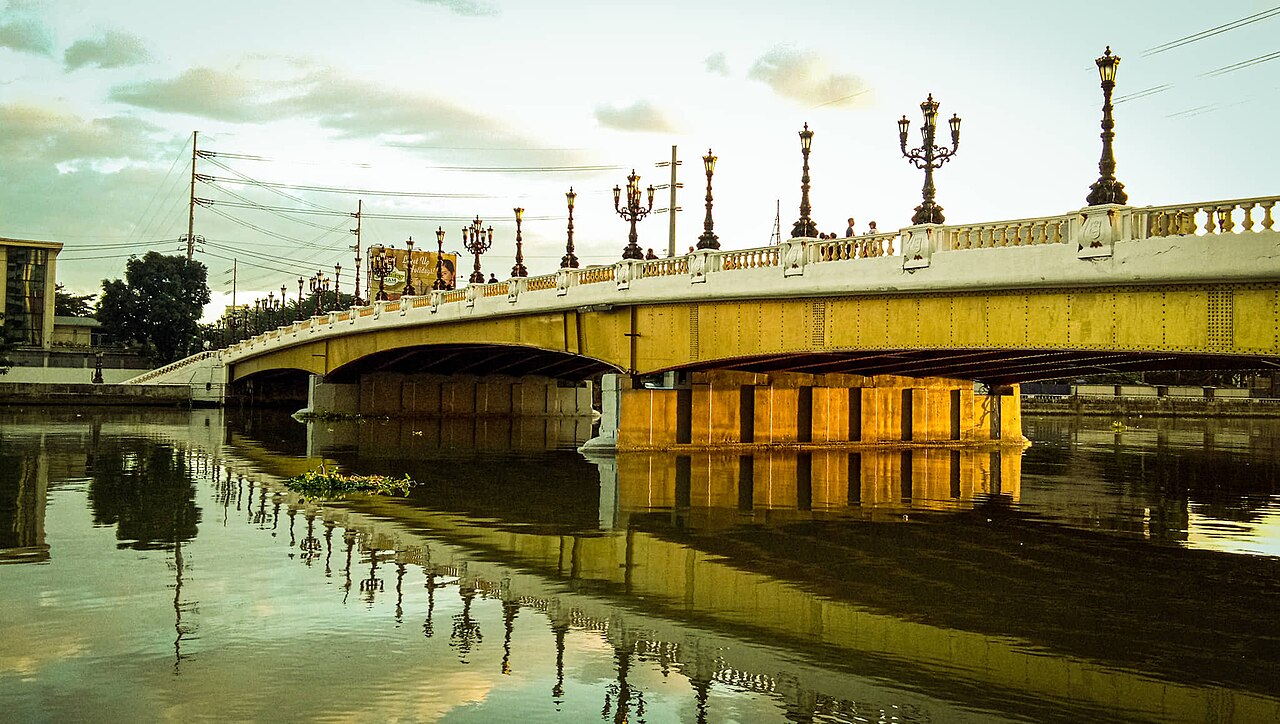
The esplanade consists of paved pedestrian space beside the Pasig River, with sections that may include seating and landscaping. The river is the central visual feature, while boats, bridges, urban buildings, heritage structures, and residential areas shape the view along different portions. It is not an enclosed attraction with galleries or a fixed exhibition route. The character changes from segment to segment, so a short riverside walk can feel different from a longer exploration. The esplanade contains a paved pedestrian walkway running parallel to the river. Seating areas may be present for rest and observation. Landscaping along the route varies by segment. The river itself constitutes the primary visual element, with passing boat traffic visible.
Checked 2026-08-26 · Source
Allow one to two hours for a meaningful walk along an accessible section, including pauses to watch the river and take photographs. The entire corridor is not a single simple loop, and a continuous end-to-end walk would require substantially more time than a typical visitor has. Thirty to forty-five minutes can suit a compact segment, while a longer visit works for travelers interested in urban landscapes and changing riverside views. Choose your distance according to the access point you use.
Checked 2026-08-26 · Source
Early morning and late afternoon reduce heat exposure and create more comfortable conditions for walking beside the river. Evening can bring a different atmosphere, but lighting varies between sections. Rain can limit enjoyment during Manila’s wetter months, while daytime weather in the drier season is generally easier for an outdoor promenade. The esplanade is made up of changing riverfront segments, so the conditions and atmosphere you encounter depend on the part of the corridor you visit.
Checked 2026-08-26 · Source
Pasig River Esplanade is public walking infrastructure, and the available place information does not identify an admission ticket or a ticketing system. Plan for transport and ordinary incidental spending rather than a stated attraction fee. Commercial venues along the surrounding streets operate separately from the promenade. The esplanade’s appeal is the chance to walk beside the Pasig River and observe Manila’s changing waterfront, not a paid indoor program or scheduled show.
Checked 2026-08-26 · Source
Access is possible from several points along the Pasig River corridor. Jeepneys and buses serve roads near the river, while the Pasig River Ferry Service provides an alternative where its relevant stops are operational. Taxis and ride-hailing services can bring you to a chosen entry point. Because the promenade is linear and divided into sections, decide whether you want a short walk or a particular riverside direction before traveling. Construction and rehabilitation work can alter local approaches.
Checked 2026-08-26 · Source
The Pasig River Esplanade is an urban outdoor route with conditions that vary between sections. Walking surfaces can be uneven or interrupted, and some parts may have limited lighting after dark. Avoid contact with the river water, which has documented quality challenges. Protect yourself from heat, sun, and sudden rain. Keep valuables close and use extra care where the promenade meets busy streets or residential areas. A daytime walk is a straightforward starting point for visitors unfamiliar with the corridor.
Checked 2026-08-26 · Source
The esplanade offers documentary views of the Pasig River, boats, bridges, urban buildings, and the contrast between formal public improvements and older riverside neighborhoods. Late-afternoon light can add warmth to the water and skyline, while evening lighting changes the mood. Respect residents’ privacy and avoid photographing people as subjects without consent. Keep cameras and phones secure, especially on quieter sections. Wide river views and details of the changing shoreline convey the promenade’s character well.
Checked 2026-08-26 · Source
The esplanade comprises multiple segments, and visitors generally experience selected portions rather than one uninterrupted end-to-end walk.
No. The river has documented water-quality challenges, and the esplanade is intended for walking and observation rather than swimming.
Allow one to two hours for a substantial section, or thirty to forty-five minutes for a compact riverside walk.
Jeepneys, buses, taxis, ride-hailing services, and the Pasig River Ferry Service where operational can serve different access points.
Expect river views, boats, bridges, urban buildings, landscaping, and changing waterfront neighborhoods along different sections.
Early morning and late afternoon generally offer less heat, while rain can affect outdoor comfort during wetter months.
Loading the interactive map…
The interactive map could not be loaded.
Last updated:
Source: OpenStreetMap contributors ·