.jpg)
1 min walk · Stari Grad
Remains of the Metropolitan Residence
- High
- Historic monument
Historic monument · Stari Grad, Belgrade
Чесма Мехмед-паше Соколовића
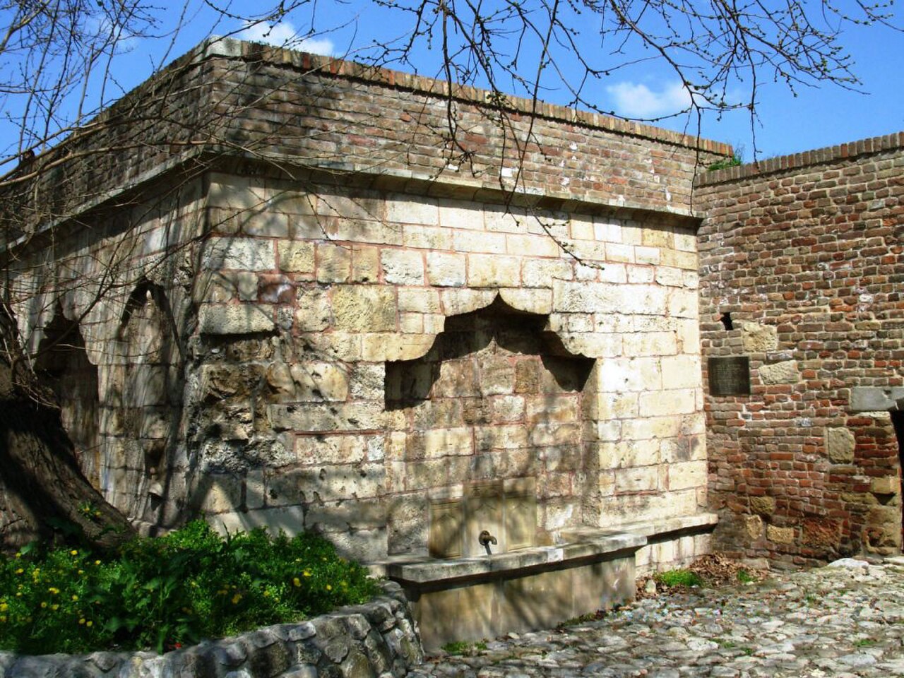
Mehmed Paša Sokolović's Fountain is a sixteenth-century Ottoman drinking fountain in the Upper Town of Belgrade Fortress. Erected between 1576 and 1577, it is the only endowment of Ottoman vizier Mehmed Paša Sokolović in Belgrade. The fountain is defined by its setting as much as by its stonework: it remains beside the route around Defterdar Gate, where visitors encounter it within the fortress rather than inside a museum. It has retained its original function as a drinking fountain. This makes the monument an unusually direct link between Ottoman patronage and everyday water provision. Its position also connects a small architectural work with the defensive routes, gates and changing political layers of Belgrade Fortress.
Checked 2026-09-02 · Source
The fountain itself is the attraction, with no interior exhibition, sequence of rooms or collection to follow. It is a restored stone monument beside the cobblestone path near Defterdar Gate. The historical setting supplies the wider explanation. When the fountain was built, it stood in a moat beneath the bridge leading to the castle's main gate, placing water access directly within a defended entrance. Today, the Upper Town route, the gate and the fortress walls provide the context that would otherwise be supplied by museum labels. Examine the fountain first, then look towards the Clock Gate opposite and trace the passage between these landmarks.
Checked 2026-09-02 · Source
Allow about 10 to 20 minutes for the fountain itself. That time is enough to identify the monument, inspect its restored stonework, understand its position beside Defterdar Gate and take photographs without reducing the stop to a passing glance. The fountain works best as one detail in a longer Upper Town circuit. Add time for the fortress walls, viewpoints, the Clock Gate and the route towards the Lower Town if you want to understand its defensive setting. A short standalone pause is sufficient for the fountain, while visitors interested in its Ottoman context may linger around the gate passage and surrounding historic layers.
Checked 2026-09-02 · Source
Daylight is the most practical time to see the fountain's stonework and understand its relationship with Defterdar Gate, the Clock Gate and the Upper Town route. Morning or late afternoon can make photography and orientation more comfortable. The monument is best approached as part of a walking circuit, with enough time to pause beside the path without obstructing people moving through the gate. Weather also matters because the route combines a downhill approach with historic paving. In clear light, the fountain's position is easier to read against the surrounding fortress walls and passage. A visit planned around the wider Upper Town gives the monument more meaning than a hurried search for the structure alone.
Checked 2026-09-02 · Source
The fountain is encountered as an outdoor monument beside the fortress route, while museums, towers, guided programmes or special events elsewhere in Belgrade Fortress may have separate arrangements. Keep those facilities distinct from the fountain itself when planning the walk. The useful expectation is a brief historical stop beside Defterdar Gate, not an indoor exhibition with a ticket desk or timed visit. This distinction matters because information about another fortress facility cannot be transferred to the fountain.
Checked 2026-09-02 · Source
Enter Belgrade Fortress's Upper Town and follow the route towards Defterdar Gate. The fountain stands beside the cobblestone path leading through Defterdar Gate towards the Lower Town, opposite the Clock Gate. Named public-transport stops serving the fortress area include Kalemegdan and Donji grad; from either stop, continue on foot through the Kalemegdan and Upper Town approaches. Once inside the complex, use Defterdar Gate and the Clock Gate as the clearest orientation points. The final approach belongs to a historic fortress landscape, so expect changes in surface and gradient rather than a modern, uniformly paved plaza. The fountain is easiest to recognise through its relationship to the gate passage and the Clock Gate across from it.
Checked 2026-09-02 · Source
The approach has limited step-free access. The restored route includes a downhill ramp made of planks, while the fountain is beside a cobblestone path near Defterdar Gate. This is not a fully step-free route with a smooth, continuous surface, so wheelchair users, people with walking difficulties and visitors pushing a stroller should assess the approach carefully. Uneven historic paving and the downhill direction require attentive movement, particularly when surfaces are wet. Stable footwear is useful, and visitors should leave room for others moving through the gate passage. These access conditions belong to the route itself and should be considered before setting out.
Checked 2026-09-02 · Source
Photograph the fountain together with Defterdar Gate, the Clock Gate opposite and the Upper Town setting. Begin with a wider composition showing the monument within the fortress passage, then take closer images of the restored stonework and drinking-fountain form. Daylight makes the surfaces easier to read and helps distinguish the fountain from the surrounding defensive masonry. Pause to one side so the cobblestone route remains usable for people passing through the gate approach. A contextual photograph is especially valuable here because the fountain's strongest visual story is its location.
Checked 2026-09-02 · Source
It was erected between 1576 and 1577.
It stands in the Upper Town of Belgrade Fortress, beside Defterdar Gate and opposite the Clock Gate.
It stood in a moat beneath the bridge leading to the castle's main gate.
It is the only endowment of the Ottoman vizier Mehmed Paša Sokolović in Belgrade.
Yes. It has retained its original function as a drinking fountain.
Extensive reconstruction and restoration works were carried out in 2017.
Loading the interactive map…
The interactive map could not be loaded.
Last updated:
Source: OpenStreetMap contributors, Wikidata ·