Santichaiprakarn Park is a small riverside park at the northern end of Phra Athit Road in Phra Nakhon, laid out in 1999 around Phra Sumen Fort on the bank of the Chao Phraya. It covers roughly 1.2 hectares, which makes it one of the smallest public parks in central Bangkok and one of the few that gives directly onto the river. The name, meaning the fortress of victory for peace, was bestowed by King Bhumibol Adulyadej in 1999, the year of his seventy-second birthday. It functions less as a green space than as a riverside terrace with a fort in it: a strip of paving, grass and shade between an old city wall bastion and the water, used by the neighbourhood in the early morning and at sunset rather than through the middle of the day.
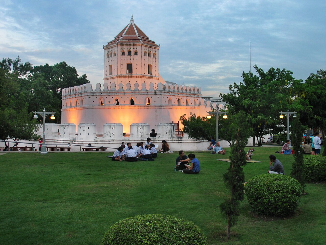
Three things give the park its character. Phra Sumen Fort, the white bastion that the park was built around, is one of the surviving fortifications of the old walled city and dominates the site from the river end. The Santichaiprakarn Pavilion, a raised open pavilion, was built to commemorate King Bhumibol Adulyadej's sixtieth birthday and gives the park its focal structure. And a single lamphu tree, Sonneratia caseolaris — the mangrove apple, described as the last one in Bangkok — stands in the park; it is the tree that gave the surrounding Banglamphu district its name, which makes a small specimen the most historically loaded object on the site. A promenade runs along the river edge with benches facing the water.
Allow about 40 minutes. Santichaiprakarn Park is a strip rather than a landscape: walking the promenade end to end, circling the base of Phra Sumen Fort, finding the lamphu tree and sitting long enough to watch a few barges pass fills that comfortably, and there is nothing further inside to extend it. Visitors who come at sunset and stay for it should allow an hour, because the point of the visit becomes the light on the water rather than the ground covered. As a stop on a Rattanakosin walk it works best as a break between longer sites rather than as a destination in itself, and 40 minutes is roughly what a break wants to be.
Early morning and late afternoon are the park's two working hours; the middle of the day is hot and largely unshaded along the promenade. In the early morning the space belongs to the neighbourhood, with aerobics and tai chi groups on the paving. Late afternoon into sunset is when the riverside benches fill, and the west-facing aspect across the Chao Phraya makes this one of the better free sunset positions in the old city. The park also serves as a viewing point for events on the river: Loy Krathong is celebrated here, Songkran is marked in April, and the Royal Barge Procession that accompanies the royal robe-offering ceremony can be watched from the bank. Expect real crowds on those dates.
Treat the tickets details as provisional when arranging this stop in Bangkok. Check the operator's own site for the travel date before relying on a schedule, fare or closure notice. Keep enough flexibility to move the visit within the same area if current conditions differ from the plan. This guide does not infer practical facts from the venue category, nearby attractions or an aggregator. Check the operator's own site for the travel date before relying on a schedule or fare.
The park lies at the river end of Phra Athit Road in Phra Nakhon District, where the road meets the Chao Phraya, and the approach is on foot. Phra Athit Road itself runs down from the park through a stretch of shophouses, cafes and guesthouses, and walking that street is part of arriving. From the Banglamphu side and from Khao San Road the walk takes only a few minutes. River boats serve piers on this stretch of the Chao Phraya, and arriving by water gives the best first sight of Phra Sumen Fort, which was built to be seen from the river rather than from the road behind it.
Phra Sumen Fort is a protected monument rather than a climbing frame; the structure is fenced and looked at from the ground rather than entered. The promenade has little shade and faces west, so a midday visit in the hot season is genuinely unpleasant and an afternoon one heats up before it cools down. Because no operator-published hours could be confirmed, a visitor arriving late in the evening may find the park shut, and this is not a site to build the end of a day around. On Loy Krathong and Songkran the park is packed and movement along the narrow riverside strip is slow. The river edge is a working waterway with barge traffic; the railings exist for a reason.
The single strongest image here is Phra Sumen Fort's white mass against the Chao Phraya, and it is a late-afternoon picture: the sun sets across the river, so the fort takes warm side light and then goes to silhouette. Shooting it from the promenade, low and close, exaggerates the bastion's height; shooting from a passing river boat gives the elevation it was designed to be seen from. The Santichaiprakarn Pavilion frames the river cleanly if the camera is placed under it and pointed out. The lamphu tree is a modest subject that needs its context — a caption, or the fort behind it — to read as anything. Early-morning exercise groups are locals in their own park, so photograph the scene rather than individual faces.
Yes. It is a public park operated by the Bangkok Metropolitan Administration and charges no admission.
What are Santichaiprakarn Park's opening hours?
Check the operator's own site for the travel date before relying on a schedule or fare.
What is Phra Sumen Fort?
Phra Sumen Fort is the white bastion the park was built around, one of the surviving fortifications of Bangkok's old walled city, standing at the river end of the site. It is viewed from the ground rather than entered.
Why is there one tree singled out in the park?
The park holds a lamphu tree, Sonneratia caseolaris or mangrove apple, described as the last one in Bangkok. It is the tree that gave the surrounding Banglamphu district its name.
How long does a visit to Santichaiprakarn Park take?
About 40 minutes covers the promenade, the base of the fort, the pavilion and the lamphu tree. Visitors staying for sunset should allow an hour.
What festivals are held at Santichaiprakarn Park?
Loy Krathong is celebrated in the park, Songkran is marked there in April, and the Royal Barge Procession accompanying the royal robe-offering ceremony can be watched from the riverbank.