
3 min walk
Urubamba Old Market
- Notable
- Market
Language · 11 published
Activity · Cusco
Reviewed by Elena Voss · Roavina Travel Editor

Urubamba is a town in Peru’s Sacred Valley of the Incas, between Cusco and Machu Picchu. It sits beside the Vilcanota River at a lower elevation than Cusco and works particularly well as a practical base for exploring the valley. Travellers come for accommodation, food, market shopping, supplies, and road connections rather than for one dominant monument. Its position makes it useful between archaeological visits, especially for journeys continuing toward Ollantaytambo and the railway to Aguas Calientes. Urubamba is a valley town in the Sacred Valley of the Incas, situated between Cusco and Machu Picchu. It serves as a practical base for travellers exploring the region and functions as a local market centre. The town lies along the Vilcanota River at lower elevation than Cusco, offering milder conditions. It is not a primary destination in itself but supports the standard Cusco regional itinerary with accommodation, supplies, and transport connections for visitors heading to surrounding archaeological sites. Not as a primary destination. It functions best as a practical base or brief stop within a broader Sacred Valley itinerary.
Checked 2026-08-26 · Source
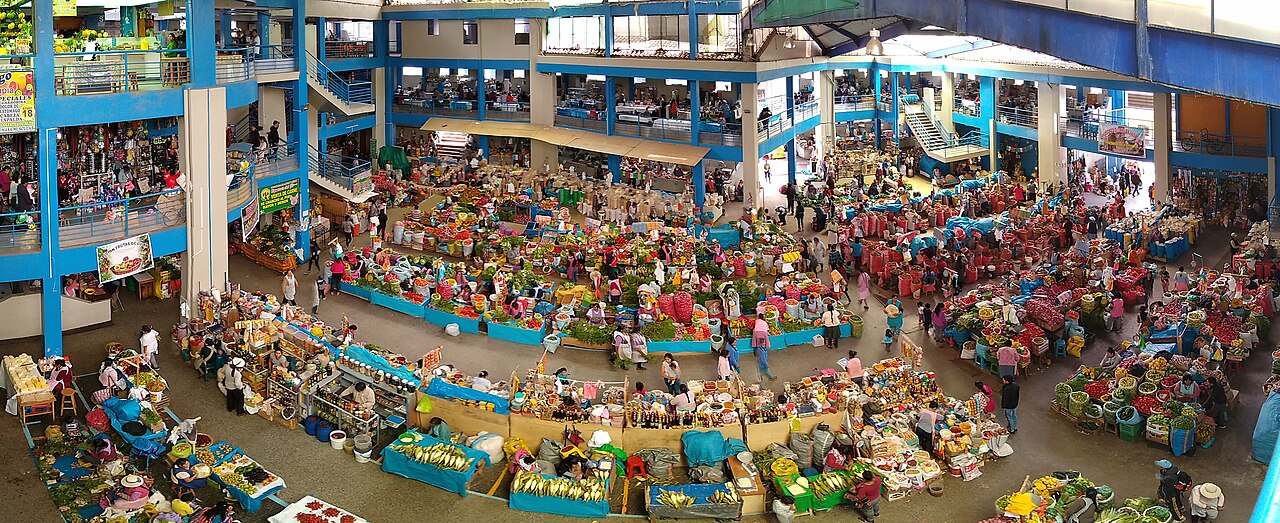
The central market is the town’s clearest point of interest, with regional produce, textiles, and everyday goods creating a direct view of local commerce. Around it are streets with small eateries, accommodation, and basic services. Agricultural land follows the river valley, while major ruins and salt pans lie outside town and require separate trips. Urubamba’s character is practical and lived-in rather than monumental. Spend time in the market, walk through the central streets, and use the town as a comfortable link between the valley’s larger sights.
Checked 2026-08-26 · Source
A market visit can take one to two hours, depending on whether you are shopping, eating, or simply observing daily life. A short stop works well during a valley transfer, while an overnight stay makes sense for travellers using Urubamba as a base. The town itself does not require a full sightseeing day for most visitors. Staying longer is valuable when it reduces repeated journeys to nearby attractions or provides a slower pause between Cusco, Ollantaytambo, and other Sacred Valley destinations.
Checked 2026-08-26 · Source
May through September is the drier season and usually brings steadier conditions for road travel and walking around town. November through March is wetter, which can make regional journeys less predictable and may reduce the comfort of outdoor visits. Market activity follows local daily life rather than a visitor timetable, so an early visit offers a useful look at trading before the day becomes busy. The valley remains changeable year-round; carry a light layer and rain protection when travelling between towns.
Checked 2026-08-26 · Source
Urubamba is an open town, so walking through its streets and entering the market does not require an archaeological admission ticket. The Cusco Tourist Ticket applies to covered archaeological attractions, not to ordinary town circulation. Keep Peruvian soles available for everyday purchases and transport. Treat Urubamba as a base within the wider valley budget rather than as a ticketed monument.
Checked 2026-08-26 · Source
Urubamba is about two hours from Cusco by road, with colectivos and buses connecting the city to the Sacred Valley. Private transport and organised tours provide alternatives when you want a fixed route or several stops in one day. The town connects onward with Ollantaytambo, where trains depart for Aguas Calientes and Machu Picchu. There is no airport in Urubamba. Road journeys follow the valley floor after crossing out of Cusco, and traffic or weather can affect the overall travel time.
Checked 2026-08-26 · Source
Urubamba is lower than Cusco but remains a highland town, so visitors may still need time to adjust. In the market, keep belongings close in busy areas and handle bargaining politely. Road conditions, maintenance, and weather can alter journeys through the valley. Local medical provision is more limited than in Cusco, which matters if you are planning remote excursions. Use ordinary food and water precautions, carry enough cash for the day, and leave generous time when connecting with onward transport.
Checked 2026-08-26 · Source
The market is the best place for documentary images of produce, textiles, stalls, and everyday trading. Early morning brings the strongest sense of activity. Ask before photographing people, particularly vendors and families, and avoid turning private moments into portraits without permission. At the town’s edges, the river valley and surrounding mountains provide broader landscape context. Crowded market lanes require compact equipment and awareness of belongings. A respectful, observational approach suits Urubamba better than searching for a single monumental viewpoint.
Checked 2026-08-26 · Source
Urubamba works best as a practical base or short stop, offering accommodation, food, market shopping, supplies, and connections between Cusco and the valley’s archaeological sites.
Urubamba has more everyday services and market activity, while Ollantaytambo is better known for preserved architecture, archaeological remains, and its railway connections toward Machu Picchu.
No. Ordinary town streets and the central market are not archaeological attractions requiring a tourist ticket. Admission costs arise when you travel onward to covered heritage sites.
The market presents regional produce, textiles, and everyday goods, making it a useful place to observe local commerce and buy practical supplies during a Sacred Valley journey.
Yes. Urubamba lies in the Sacred Valley at a lower elevation than Cusco, although it is still a highland town and visitors may need time to adjust.
Travel onward by road to Ollantaytambo, where railway services depart for Aguas Calientes and the Machu Picchu access route.
Loading the interactive map…
The interactive map could not be loaded.
Last updated:
Source: OpenStreetMap contributors, Wikidata ·