Roavina

City guide · Türkiye

Manisa

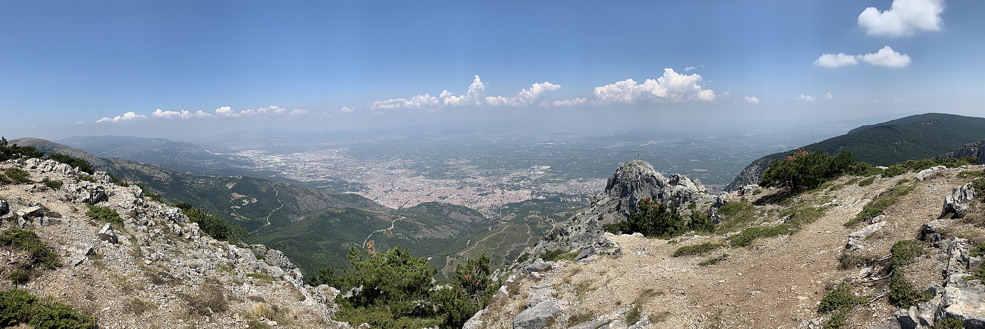
A photograph of Manisa
Photograph · Egemenakgul · CC BY-SA 4.0

Manisa sits on the Gediz plain about 40 km northeast of İzmir, with Mount Spil rising 1,513 m directly behind it. The old town climbs the mountain's lower slopes; everything built since spreads north across the plain. The city is an Ottoman provincial capital rather than a resort. Süleyman the Magnificent governed here as a prince, and the mosques his family endowed are still the reason to come: the Sultan Mosque of 1522, the Muradiye of 1586 by Mimar Sinan, and the museum that occupies the Muradiye's medrese. Above them the national park holds the Weeping Rock of Niobe and an eight-metre Anatolian relief cut into the cliff along the D250.

Reviewed by Elena Voss · Roavina Travel Editor

Practical information

Language spoken
Turkish
The official language of the Republic of Turkiye
Dialling code
+90 236
Manisa landlines; drop the leading 0 of 0236 when calling from abroad
Currency
Turkish lira (₺, TRY)
The official currency; one lira is divided into 100 kurus
Emergency number
112
One number for ambulance, fire and police
Plug type
European two-pin · 220 V
The national living guide records 220 V and European-style two-pin plugs
Tap water
Not recorded
No verified national source in the dataset

Turn this list into a plan

Set your days, your pace and the hours you actually want to be out. The planner works around closing days and travel time, and leaves room to eat.

Plan Manisa

Planning a visit

Suggested stay
1–2 days
Getting around
On foot, plus a car for the mountain
  1. January: viable with meaningful trade-offs
  2. February: viable with meaningful trade-offs
  3. March: good time to visit
  4. April: best time to visit
  5. May: best time to visit
  6. June: viable with meaningful trade-offs
  7. July: recurring difficult conditions
  8. August: recurring difficult conditions
  9. September: good time to visit — current month
  10. October: best time to visit
  11. November: good time to visit
  12. December: viable with meaningful trade-offs
  • Best time
  • Good time
  • Viable with trade-offs
  • Difficult conditions

Sources

Top things to see

Ranked by importance — sitelinks, pageviews and heritage status, not editor preference.

  1. Kula Volcanic Geopark Kula Volcanic Geopark
    02 4 hours

    Kula Volcanic Geopark

    Kula Volkanik Jeoparkı

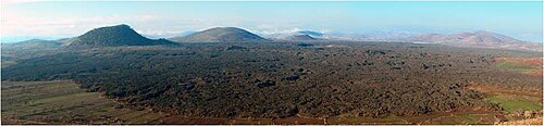
    Kula-Salihli UNESCO Global Geopark, signed locally as Kula Volkanik Jeoparkı, is a 2,320 square kilometre protected volcanic landscape spanning the Kula and Salihli districts of Manisa Province, roughly 100 km east of Manisa city.

    • Must see
    • Nature site
    • Kula
  2. Mount Spil National Park Mount Spil National Park
    03 4 hours

    Mount Spil National Park

    Spil Dağı Millî Parkı

    Spil Dağı Milli Parkı is the protected forest on the mountain behind Manisa, opened to the public on 22 April 1968.

    • Must see
    • Nature site
    • Şehzadeler
  3. Weeping Rock of Niobe Weeping Rock of Niobe
    04 35 min

    Weeping Rock of Niobe

    Niobe Ağlayan Kaya

    The Weeping Rock of Niobe — Ağlayan Kaya on the roadside marker — is a natural cliff formation on the northern flank of Mount Sipylus above Manisa, in Dere Mahallesi — formerly Karaköy — at Çaybaşı, along the stream of…

    • Must see
    • Viewpoint
    • Şehzadeler
  4. Kula Fairy Chimneys Viewing Terrace Kula Fairy Chimneys Viewing Terrace
    05 30 min

    Kula Fairy Chimneys Viewing Terrace

    Kula Perbacaları seyir terası

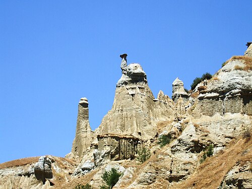
    Kuladokya is a fairy-chimney viewing terrace and 1.2 kilometre walking trail inside the Kula-Salihli UNESCO Global Geopark, near Yurtbaşı village on the İzmir-Ankara highway, about 16 km from Kula town.

    • Must see
    • Viewpoint
    • Kula
  5. Kula volcano Kula volcano
    06 1 hour

    Kula volcano

    Kula

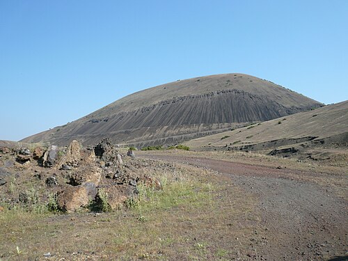
    Kula Volcano is an extinct cinder cone in the Kula volcanic field, the feature that gives the field and the surrounding Kula-Salihli Geopark their name.

    • Must see
    • Viewpoint
    • Kula
  6. Divlit Volcano Divlit Volcano
    07 2 hr 30 min

    Divlit Volcano

    Divlit Yanardağı

    Divlit Yanardağı, known locally as Çakallar Tepesi or Divlittepe, is a cinder cone on the shore of the Demirköprü Reservoir in Kula district, at roughly 750 m above sea level.

    • Must see
    • Viewpoint
    • Kula
  7. Lava Cave
    08 1 hour

    Lava Cave

    Lav Mağarası

    Lav Mağarası is a named lava-cave geosite in Kula Divlit Volcanic Park, within Kula district of Manisa. It is a natural volcanic formation rather than a built attraction with galleries, lighting or exhibition rooms.

    • Must see
    • Nature site
    • Kula
  8. Manolya Meydanı
    09 1 hour

    Manolya Meydanı

    Manolya Meydanı is a named public square in central Manisa where everyday movement, meetings and civic activity come together.

    • High
    • Nature site
    • Şehzadeler
  9. Necdi Şentürk Şehir Parkı
    10 1 hour

    Necdi Şentürk Şehir Parkı

    Necdi Şentürk Şehir Parkı is an urban recreation area in İnönü Mahallesi, within Akhisar’s central Kültürpark area in Manisa province. It is also referred to as Kültürpark and Şehit Yüzbaşı Necdi Şentürk Parkı.

    • High
    • Nature site
    • Akhisar
  10. Çetinkaya Park
    11 1 hour

    Çetinkaya Park

    Çetinkaya Park is a neighbourhood outdoor park on Bahtiyar Tosunbaş Caddesi in Hafsa Sultan, Yunusemre, Manisa. Its defining documented feature is a network of running paths renewed with an acrylic surface by Yunusemre Municipality’s Park and Gardens Directorate.

    • High
    • Nature site
    • Yunusemre
  11. İrpek Tepe
    12 20 min

    İrpek Tepe

    İrpek Tepe is a natural summit in Manisa Province’s Yuntdağı area, in countryside associated with Davutlar and Demirci. The summit stands at approximately 670 metres and is an outdoor walking destination rather than a staffed attraction, museum or archaeological site.

    • Notable
    • Viewpoint
    • Yunusemre
  12. Yağcı Dağı
    13 20 min

    Yağcı Dağı

    Yağcı Dağı is a 1,516-metre mountain in Selendi district of Manisa Province, among the principal elevations north of Selendi. Its appeal is the high, forested landscape rather than buildings or exhibitions.

    • Notable
    • Viewpoint
    • Selendi
  13. Buğday Tepe
    14 20 min

    Buğday Tepe

    Buğday Tepe is a 1,308-metre natural summit in the mountainous surroundings of Buldan district in Denizli Province, close to the Manisa provincial border. Its appeal is the open mountain landscape rather than a building, collection or staffed attraction.

    • Notable
    • Viewpoint
    • Sarıgöl
  14. Turan Bayraktepe Seyir Terası
    15 20 min

    Turan Bayraktepe Seyir Terası

    Turan Bayraktepe Seyir Terası is a mountain viewpoint in the summit area of Spil Dağı Milli Parkı above Manisa. Its character comes from the open mountain setting and the elevated outlook, rather than from an enclosed exhibition or built collection.

    • Notable
    • Viewpoint
    • Şehzadeler
  15. Hamam Tepe
    16 20 min

    Hamam Tepe

    Hamam Tepe is a natural mountain summit in Manisa Province, within the Bozdağlar range. At 800 metres, it is an open landscape rather than an enclosed attraction, museum or staffed visitor facility.

    • Notable
    • Viewpoint
    • Sarıgöl
  16. Kocagöl Tepe
    17 20 min

    Kocagöl Tepe

    Kocagöl Tepe is a mapped natural peak in Sarıgöl district of Manisa Province, near the named locality of Karacaali. Its identity is defined by open hillside and summit landscape rather than buildings, exhibitions or staffed visitor services.

    • Notable
    • Viewpoint
    • Sarıgöl
  17. Hanımkaya Tepesi
    18 20 min

    Hanımkaya Tepesi

    Hanımkaya Tepesi is a natural peak in Manisa Province, in the Demirci area, near the localities of Ulacık and Kulalar.

    • Notable
    • Viewpoint
    • Gördes

Source: OpenStreetMap contributors, Wikidata ·

More city guides

Where to base yourself

District boundaries come from OSM administrative relations, so a district page holds exactly the places inside it — plus, for the islands and the coast, the nearest district by proximity.

  • Şehzadeler

    Places
    87
    Across the district
    9 hr 24 min
  • Salihli

    Places
    54
    Across the district
    11 hr 27 min
  • Akhisar

    Places
    75
    Across the district
    12 hr 13 min
  • Yunusemre

    Places
    86
    Across the district
    9 hr 17 min
  • Kula

    Places
    29
    Across the district
    8 hr 43 min
  • Alaşehir

    Places
    47
    Across the district
    9 hr 48 min
  • Sarıgöl

    Places
    33
    Across the district
    6 hr 56 min
  • Selendi

    Places
    16
    Across the district
    8 hr 55 min
  • Gördes

    Places
    18
    Across the district
    11 hr 29 min
  • Turgutlu

    Places
    28
    Across the district
    7 hr 54 min
  • Soma

    Places
    17
    Across the district
    7 hr 47 min
  • Demirci

    Places
    14
    Across the district
    9 hr 28 min
  • Gölmarmara

    Places
    9
    Across the district
    5 hr 43 min
  • Ahmetli

    Places
    12
    Across the district
    4 hr 34 min
  • Saruhanlı

    Places
    14
    Across the district
    11 hr 8 min
  • Kırkağaç

    Places
    9
    Across the district
    8 hr 51 min
  • Köprübaşı

    Places
    3
    Across the district
    7 hr 24 min

How the city is laid out

Manisa reads as two strips: the historic quarter on the slope, and the modern city on the plain below it. The two central districts follow that split — Şehzadeler holds the Ottoman core, Yunusemre the newer development and the Celal Bayar University campus.

Everything a visitor comes for is in Şehzadeler, and it is walkable. The Sultan Mosque, the Muradiye and the museum stand within a few hundred metres of each other on the slope, and the bazaar streets run downhill from them. The hill attractions begin roughly 1 km south of the centre, where the streets give out and the national park starts.

North of that line the city is a working Aegean provincial capital: apartment blocks, the university, industry on the Gediz plain. It is not hostile to visitors, it simply has nothing for them. Plan on foot in Şehzadeler and on wheels for anything above or beyond it.

Checked 2026-08-23

Getting around

Manisa is a walking city in the part that matters, and a driving one everywhere else.

The central monuments sit within a few hundred metres of each other on the slope, so the Ottoman core needs no transport at all. Town buses run the main streets for the rest of the city. Mount Spil National Park, the Weeping Rock and the Cybele relief are outside walking range — the relief is carved into the cliff along the D250 — and a car or a taxi is the practical way to reach them.

Arriving is easy from İzmir. Four trains a day leave İzmir Basmane and take about 90 minutes; local buses cover the same 40 km in about 35 minutes on the six-lane highway. Buses running between İstanbul and İzmir call at Manisa, hourly or better, and take about six and a half hours from İstanbul. The nearest airport is İzmir Adnan Menderes, roughly 65 km away.

Checked 2026-08-23

Common questions

How many days does Manisa need?

One full day covers the Ottoman core in Şehzadeler on foot — the Sultan Mosque, the Muradiye and the museum stand within a few hundred metres of each other. A second day is worth it only if you are going up Mount Spil or out to the Cybele relief, both of which need a car.

When is the Mesir Macunu Festival?

Every year from 21 to 24 March, at the Sultan Mosque. The paste is prepared from 41 spices and herbs, wrapped in paper, and thrown from the minaret and domes to the crowd below. UNESCO inscribed the festival on its Representative List of the Intangible Cultural Heritage of Humanity in 2012.

How do I get to Manisa from İzmir?

Four trains a day leave İzmir Basmane and take about 90 minutes. Local buses cover the same 40 km in about 35 minutes on the six-lane highway. İzmir Adnan Menderes is the nearest airport, roughly 65 km away.

What is Mount Spil and can I get up it?

Mount Spil — Mount Sipylus — is the 1,513 m mountain immediately south of the city, and its national park is the reason most Turkish visitors come. It holds forest, wild horses and hiking routes, along with the Weeping Rock associated with the legend of Niobe. The hill attractions start about 1 km south of the centre and a car or taxi is the practical way up.

Is Manisa a day trip from İzmir or a place to stay?

It works as a day trip: 90 minutes by train each way leaves a full day for the Ottoman core. Stay overnight if you want Mount Spil as well, or if you are here in the last week of March for the Mesir festival, when the city fills.

What is the Cybele relief?

An eight-metre figure of an Anatolian mother goddess cut into a cliff face along the D250, several kilometres east of the city. It is Hittite work and predates everything Ottoman in Manisa by well over two thousand years.