
12 min walk
El Rastro
- Must see
- Market
Language · 11 published
Nature site · Madrid
Reviewed by Elena Voss · Roavina Travel Editor
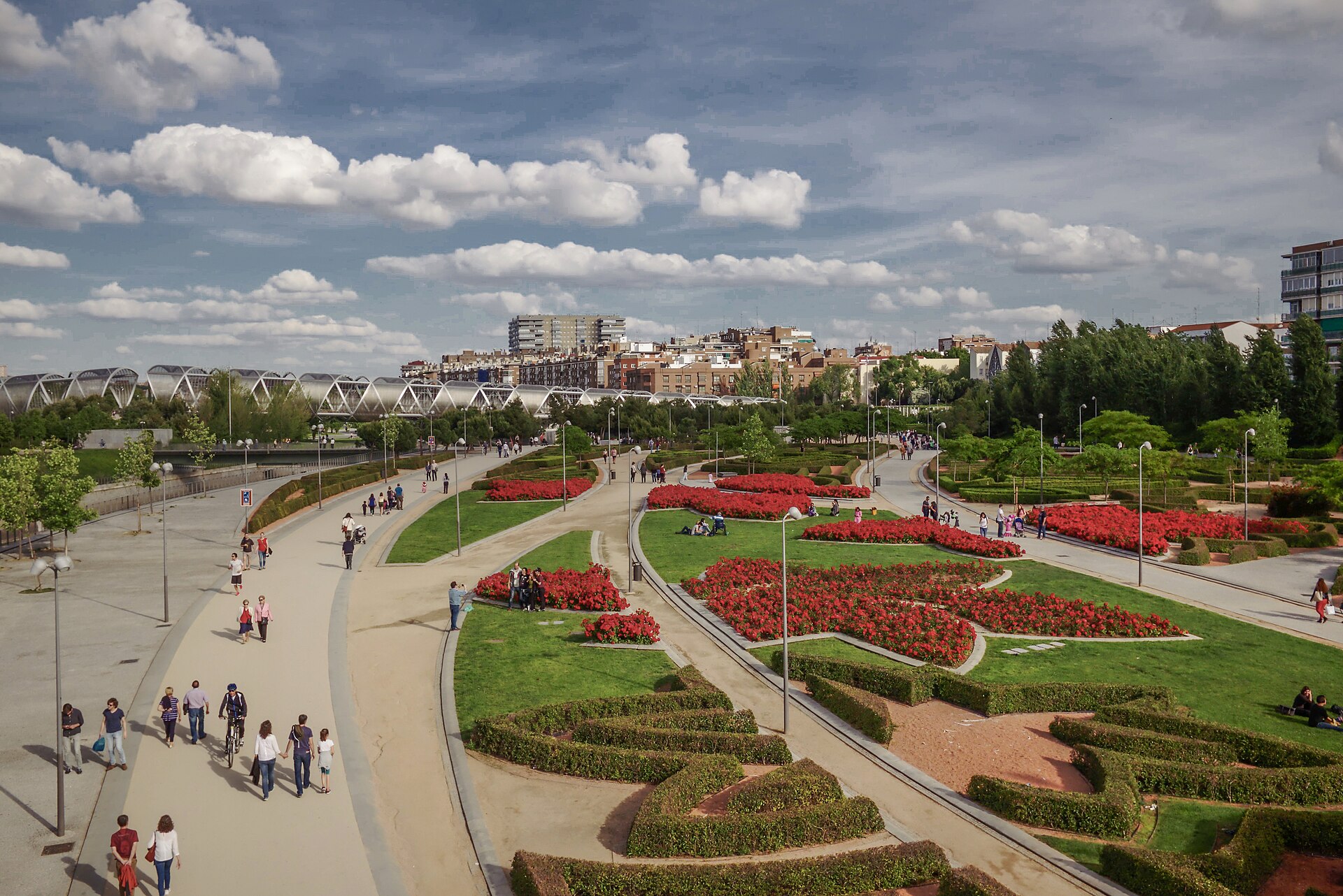
This place is a Park. It opened in 2011. It was designed by Carlos Rubio Carvajal.
Madrid Río is a long urban park and green corridor beside the Manzanares River in Madrid. It occupies the riverbanks reshaped after the M-30 ring road was placed underground, creating a broad public landscape for walking, cycling, recreation, and rest. Because the park links several districts, it works both as a destination and as a pleasant route between neighbourhoods. Its character is open, spacious, and distinctly urban, combining river views with modern public design. Madrid Río is a major urban park and green corridor running alongside the Manzanares River in Madrid, Spain. The project transformed the riverbanks following the burial of the M-30 ring road underground, creating extensive public recreational space. It spans multiple districts and serves as a significant example of urban regeneration. The park connects various neighborhoods and provides residents and visitors with accessible green infrastructure in a densely populated European capital. Its development represents one of Madrid's most substantial public works investments in recent decades. The park generally functions as public open space, but visitors should verify current access conditions and exercise caution after dark.
Checked 2026-08-26 · Source
The park brings together landscaped gardens, riverfront promenades, walking paths, cycling routes, lawns, fountains, shaded seating, sports areas, and children’s play spaces. Several pedestrian bridges cross the Manzanares. The Arganzuela Footbridge, designed by Dominique Perrault, is one of the most recognisable structures along the route. Matadero Madrid borders part of the park and adds a cultural stop to an outdoor visit. The different zones support both active outings and slower pauses beside the water.
Checked 2026-08-26 · Source
Allow one to three hours for a relaxed visit, depending on which stretch you choose and whether you stop at playgrounds, bridges, lawns, or Matadero Madrid. A short walk along one section can fit easily into a city day, while cycling lets you cover more of the elongated corridor. Families may want extra time for play areas, and walkers can build a longer half-day outing by linking several sections. The park’s flexible layout suits both brief breaks and extended exploration.
Checked 2026-08-26 · Source
Spring and autumn are especially comfortable for walking and cycling because temperatures are milder. Summer visits work well in the morning or later in the day, when the strongest heat is less intense. Early hours are suited to runners and cyclists seeking a quieter atmosphere, while warm evenings bring more outdoor activity. Winter remains suitable for a brisk walk. Choose clothing and water according to Madrid’s dry, sunny climate, particularly when planning a long stretch without an extended indoor stop.
Checked 2026-08-26 · Source
General access to Madrid Río is free because it is public parkland rather than a gated attraction. The park itself does not require advance booking for an ordinary walk, cycle, or riverside pause. Nearby venues and commercial services follow their own arrangements: an exhibition or performance at Matadero Madrid may have separate conditions, while food, drinks, rentals, and organised activities are paid directly to the provider. Plan the park visit as a free outdoor part of a wider Madrid itinerary.
Checked 2026-08-26 · Source
Madrid Río has many access points because it runs through several districts. Metro stations and bus routes serve different sections, so choose the entrance closest to the bridge, playground, promenade, or Matadero Madrid area you want to visit. Western stretches can be reached on foot from central landmarks including the Royal Palace area. The park also connects with Madrid’s cycling network. Driving is less convenient near popular entrances because parking is limited and demand can be high.
Checked 2026-08-26 · Source
Madrid’s summer sun can make a long riverside walk demanding, so carry water and protect yourself from direct exposure. Give way carefully where cyclists and pedestrians share routes, especially near busy bridges and recreation areas. Watch children closely around the river and water features. The park’s length means conditions and crowd levels vary from one section to another. After dark, stay on well-lit, active paths and keep valuables secure in crowded areas. Temporary works can affect individual facilities or paths.
Checked 2026-08-26 · Source
Madrid Río offers photographs of the Manzanares, modern bridges, landscaped banks, open lawns, and Madrid’s changing urban skyline. The Arganzuela Footbridge gives strong geometric lines and distinctive architectural framing. Morning and late-day light can bring softer reflections across the water and warmer tones to the structures. Move between sections for different viewpoints rather than relying on one overlook. Photograph other park users respectfully, and use a tripod only where it does not obstruct shared paths or entrances.
Checked 2026-08-26 · Source
It is best for a riverside walk, cycling, children’s play, bridge photography, and an outdoor break close to central Madrid.
Yes. Ordinary access to the public park is free; nearby cultural venues, food, rentals, and special activities may charge separately.
Yes. Cycling routes run through the park and connect with Madrid’s wider cycling network.
The Arganzuela Footbridge, designed by Dominique Perrault, is a distinctive subject for geometric architectural photographs.
Plan one to three hours, or longer if you cycle a substantial distance, use the play areas, or combine the park with Matadero Madrid.
Yes. Children’s play areas, open lawns, promenades, and spacious recreational zones make it suitable for a family outing.
Loading the interactive map…
The interactive map could not be loaded.
Last updated:
Source: OpenStreetMap contributors, Wikidata ·